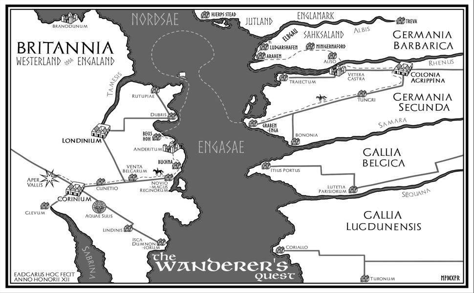
Western Europe, 395CE
Westerland grew from a question asked while watching Channel 4’s Time Team archaeology series, specifically the Turkdean episodes (Series 5, Episode 4 and Series 6, Episode 9, 1998/1999–see Bookshelf, below).
During the dig, a potsherd was unearthed. As usual, the experts identified its fabric, origin, and date, and the graphics team produced a fine reconstruction. But what I wanted to know was: who broke it and what were the consequences? This novel grew from my imagined answers to those and other questions.
Westerland
In the story, the Saxon, Eadgar, is unfamiliar with Britannia, knowing only of a territory to the west that was lost under the waves, from old stories told around the fire. On his journey, he meets other Germanic folk who name it Engaland—narrow land—from its shape.
When he learns that he must travel to Westerland, he recalls a verse:
Bright meadows vanished,
devoured by wrathful tides;
Westerland’s hills shattered,
all life forsaken.
This could be seen as a memory of the loss of Doggerland, the fertile plain that connected Britain to continental Europe and home to Mesolithic communities for millennia. Around 6,200BCE, a massive section of the continental shelf collapsed into the Norwegian Sea. Known as the Storegga Submarine Landslide, it caused large areas of land to disappear beneath the waves. Fishermen still dredge up artefacts from the North Sea, evidence of a lost population.
Eadgar’s folk, living on that coastline’s eastern edge, likely preserved the memory as legend. The capacity for such transmission across millennia is well documented: the Klamath people of Oregon still tell of a great battle between sky and earth spirits, culminating in the collapse of a vast mountain and the creation of a deep lake. Geologists have matched this to the eruption and caldera collapse of Mount Mazama, 7,700 years ago, a cataclysm accurately preserved across some 300 generations. If the Klamath can remember a volcanic event for 7,700 years, it is easy to imagine that European coastal communities could carry the memory of the drowned western lands across 8,000 years.
The song Westerland by Die Ärzte, celebrating the seaside town on the island of Sylt—lying off the coast of the Jutish homeland and visible on the map above—may also have been a factor in the story’s naming.
The Cotswolds, Turkdean and the Fosse Way
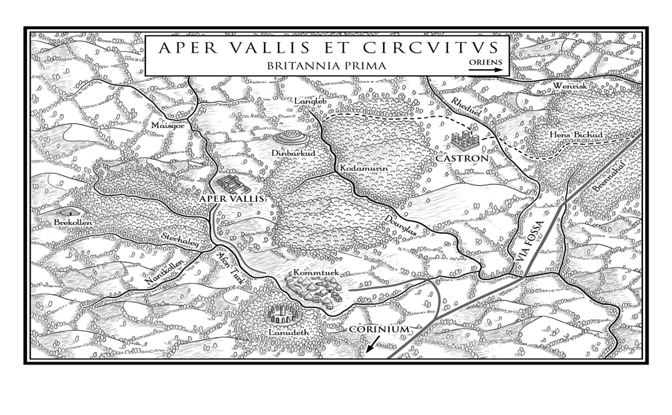
he Aper Vallis map covers the real Cotswolds landscape around Turkdean, Gloucestershire, and depicts the key locations from the story. Credit for the beautifully-drawn maps in the book goes to the illustrator, Sarah Waites.
The Fosse Way, the Via Fossa, was the great Roman highway, running up from the coast at Exeter through Aquae Sulis (Bath) and Corinium (Cirencester) and on north to Ratae (Leicester). The fort at Castron (Cold Aston) stood guard on this vital artery.
Kommturk, based on modern Turkdean, is named for the Celtic river-god, the sacred boar, Twrch. Local Brythonic Komm Turch (boar valley) became Saxon –denu and eventually –dean, as the locals translated for the new ascendency. An identically named Cwmtwrch exists today in Wales, north of Swansea, on its own Afon Twrch. The villa’s Latin name, Aper Vallis—Boar Valley—preserves the same ancient meaning.
To the west, Brekollen marks Hazelton, site of a Neolithic long barrow, as referenced by Indiana in the opening sequence of Raiders of the Lost Ark. Serena also visits the site in search of buried treasure and we hear the origins of Dr Jones’s golden coffin legend.
The druid sanctuary Lanudeth is based on Judith’s Grove, the site of a woodland still standing today. The name echoes Welsh llwyn, grove and -udeth, perhaps from Cornish yow (young) and Welsh dwdd (water).
To the north, the river Wendrisk, the modern Windrush, is likely derived from Brythonic wen reisko: white fen or rushes. The river carries its own immigrant story, giving its name to the Empire Windrush, the ship which brought new blood to be blended with long tradition. In this story, it is the Saxons themselves who are the fresh arrivals, the immigrants, their distinctiveness adding to that of the Celtic and Romanised indigenous population.
Historical Context
395CE was the year Theodosius died, splitting the empire permanently. Roman Britain still functioned, just. The last generation who would have called themselves both Roman and British, before Honorius directed the island’s cities to “look to their own defences” in his rescript of 410CE, effectively ending four centuries of Roman administration.
The first Saxon settlers were already present by this time, and had been for several generations, possibly invited by the usurper emperor Carausius as foederati around 288CE, and given land in exchange for their military service. In the village below the villa, Saxon rectangular buildings stand alongside British roundhouses.
In the story, we see the start of the process that will eventually lead to English, as the local Britons mangle the proper Saxon of the newcomers–much to Eadgar’s disgust. Professor John McWhorter of Columbia University, whose work on language contact and English’s Celtic roots informs this aspect of the story, kindly reviewed the relevant scenes, providing suggestions and praising them as ‘delightful’.
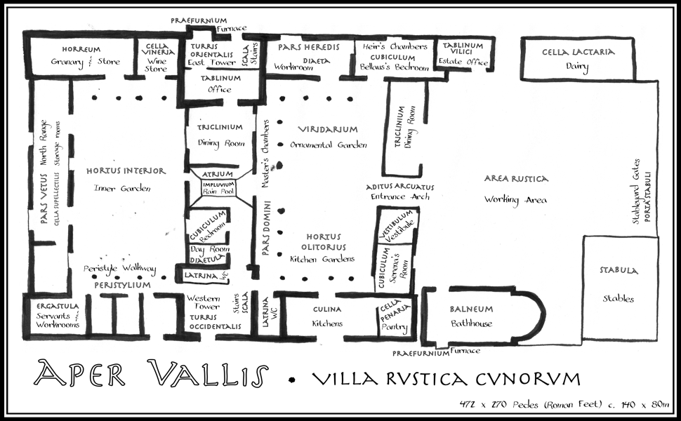
Aper Vallis
Location
The Turkdean site was occupied through the late Roman period and possibly into the first half of the 5th century, as evidenced in nearby Corinium(Cirencester). Using the Time Team discoveries and Neil Holbrook’s archaeological report (see Bookshelf, below) I have reimagined the villa as it might have been, populating it with characters inspired by Sir Tony Robinson’s “toga-wearing Brits”.
Behind the Walls
When John Gater and the Time Team geophysics crew surveyed the fields above Turkdean, they revealed the outline of a substantial Romano-British villa beneath the turf. Hypocausts, corridors, and a probable bathhouse. The trenches divulged physical evidence: pottery, coins, and a fragment of stone, enigmatically inscribed “Fil”, that appears in the story. The backstory of the “Felix”—or “Trevor”—brooch is also disclosed.
Victor Ambrus’s evocative pen and watercolour sketches brought the discoveries to life for television audiences, helping us picture what the buildings might once have looked like. His work, more than any other single influence, helped me to imagine the villa as a home and working estate, a living presence.
Neil Holbrook’s meticulous site report filled in the details. The phasing, the finds catalogue, the careful interpretation of the evidence. The coin Serena tosses and loses was one discovered at Turkdean. A sherd of the black burnished-ware jar broken by Audia is listed in the finds catalogue.
Aper Vallis is my imagining of how those fallen walls once looked, what they once contained. The people who ate in the triclinium, argued in the tablinum, bathed in the balneum, grew vegetables in the kitchen gardens. In the story, we watch as Serena ‘debugs’ the faulty heating system and as Eadgar views the bathhouse with wonder.
Parts of the novel were written sitting on that hillside, imagining how it must have looked, with bright, whitewashed walls rising around me. My imagination was further helped by visits to nearby Chedworth (Villa Fontis Rosae in the story, from Pinkwell, the site of a Neolithic long barrow) and the Villa Julia Felix in Pompeii.
Credit to my daughter, Ailish Phillips, for the elegant, hand-drawn villa plan, capturing the style of an antiquarian’s draft.
